

Google Maps is the undisputed king of all navigation apps but it also has its flaws. One of them is location accuracy while driving through tunnels. You must have noticed that the Google Maps app often fails to locate your position while driving through a tunnel. This is because of the lack of GPS signal inside the tunnel. The good news is that Google has found a way around this problem, albeit with a little help from its subsidiary navigation app, Waze. Here’s how you can enable the in-tunnel navigation feature on Google Maps.
Read Also: Gmail’s new unsubscribe button for Android: Check out how you can use it
In This Article
How does the in-tunnel navigation feature on Google Maps work?
Tunnels and underground areas are generally dead zones for GPS and cellular services. So how does Google manage to provide its navigation services in such situations? The answer is Bluetooth beacons. A ‘Bluetooth beacon’ is essentially a transmitter that sends Bluetooth signals to nearby devices. Google’s subsidiary navigation service Waze utilises these beacons to feed location data to the active devices in the area.
The data is transmitted to the device through a one-way signal. This means that the beacon does not access user data from the user’s device. At present, Waze has active Bluetooth beacons across popular tunnels in major cities like Paris, Rio, New York City, Chicago, Mexico City, and others. Google is expected to expand this network to bring better navigation support to its users. Check out how you can make your device receive this signal on the Google Maps app.
Enable in-tunnel navigation on Google Maps
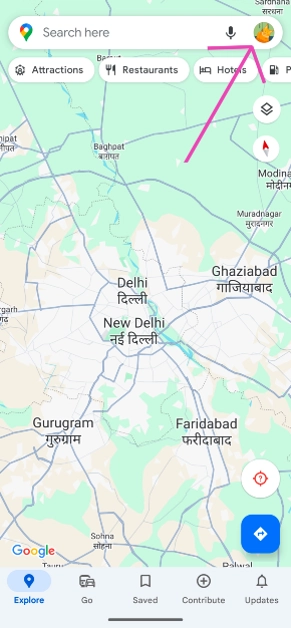
Step 1: Launch the Google Maps app on your smartphone.
Step 2: Tap on your profile icon at the top right corner of the screen.
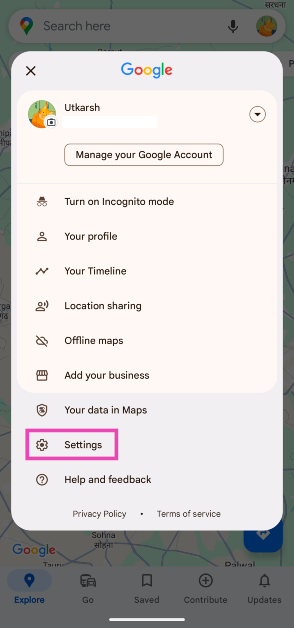
Step 3: Select Settings.
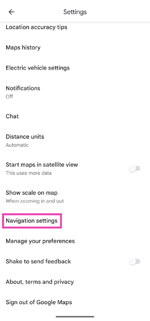
Step 4: Scroll down and select Navigation settings.
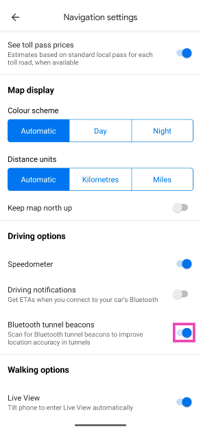
Step 5: In the Driving options section, turn on the toggle switch for Bluetooth tunnel beacons.
Frequently Asked Questions (FAQs)
How do I enable in-tunnel navigation on Google Maps?
Go to Profile>Settings>Navigation settings and turn on the toggle switch for Bluetooth tunnel beacons.
How do I find the postal address of a location on Google Maps?
Drop a pin on the location, tap on it, and swipe up the results page to view the full postal address of the location on Google Maps.
How do I measure the distance between two points on Google Maps?
Press and hold the starting point to drop a pin on it. Now, swipe up and select ‘Measure distance’. Drag the map to the final point to measure the distance between them.
Conclusion
This is how you can enable the in-tunnel navigation feature on the Google Maps app on your smartphone. Google is currently rolling out this feature in phases across Android devices. iPhones will receive this feature later down the line. If you have any questions regarding this feature, let us know in the comments!
