

While Google Maps may have a satellite view, Google Earth has a more extensive set of functions and several layers for you to view the map in. You can also make a custom layer and decide what things you want to see on the map. Google Earth also lets you calculate the area of any plot of land. On top of that, you can also see previously recorded satellite views for any given location. In this article, we bring you three simple ways to get a satellite view of your house using Google Earth.
Read Also: The Hidden Truth Behind Online Gaming Revealed
In This Article
How to use Google Earth on a Desktop
Step 1: Download Google Earth Pro for desktop from the official website.
Step 2: Launch Google Earth Pro on your desktop and enter your address in the search bar.

Step 3: Click on the plus icon on the right side of the screen to zoom in.

Step 4: Drag the Pegman icon to the desired location to have a look at the Street View.
Step 5: Click on Tools and use the ruler to measure the length or area of any plot of land.
Step 6: Go to View>Historical Imagery to see what the location looked like when Google Earth first recorded its Satellite View.
How to use Google Earth on a web browser
Step 1: Go to https://earth.google.com/web/ and search your address.
Step 2: Drag the Pegman icon to have a look at the Street View.
Step 3: Select the Measure icon from the side menu to calculate the area of any plot of land.

Use Google Maps on your smartphone
Step 1: Launch the Google Maps app on your smartphone and navigate to your preferred location.
Step 2: Tap the layers icon on the screen.
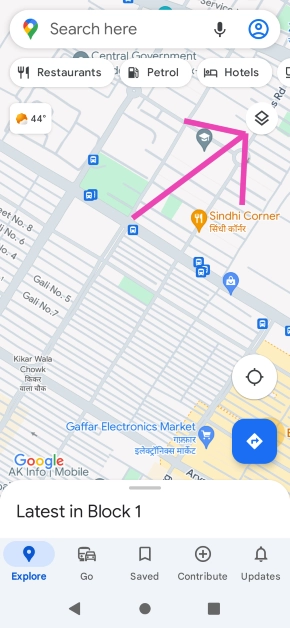
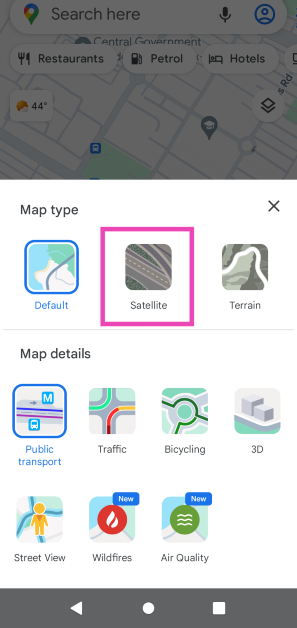
Step 3: Select Satellite.
Read Also: Poco C50 budget smartphone with a 5,000mAh battery launched in India
Frequently Asked Questions (FAQs)
How do I get the satellite view of my house on my PC?
Download Google Earth or go to its official website and navigate to your address to get a satellite view of your house.
How do I get the satellite view of my house on my phone?
Download the Google Earth app for Android or simply switch to the Satellite layer in the Google Maps app.
Does Google Earth show satellite visuals in real-time?
No, the visuals on Google Earth are not in real-time. However, they are updated periodically.
Conclusion
These are the three simple ways you can get a satellite view of your house using Google Earth. Google Earth also lets you explore interesting locations as a part of virtual tours using the ‘Voyager’ function. You can even create a guided tour for any location on Google Earth. If you found this article helpful, let us know in the comments!
